The
Apache Trail (State Route 88) is a scenic byway that winds
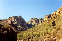
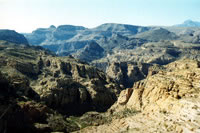
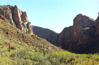
through the north side of the Superstition Mountains on its
way to Roosevelt Dam. It follows Canyon and Apache lakes to Roosevelt
Dam. Elevations in the Superstitions vary from 2,000-6,000
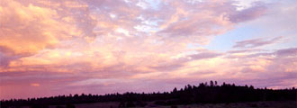
ft. The terrain in parts can be very unforgiving. The road is designated as an Arizona Historic Trail. Travel on the road is an adventure, and visitors are rewarded with spectacular scenery.
 |
|
| |
For Families: |
Driving the trail can be an enjoyable day outing. If you live in the area, don't miss out on this experience. There are several picnic areas, and one nice area even has a boardwalk over the lake. However, make sure you get a Tonto Day Use Pass if you want to stop for more than just pictures or a restroom break.
Parts of the road are windy, so children (and adults) who are prone to car sickness may have a rough trip.
|
|
|
| |
|
En route, the trail passes by a replica
of the ghost town of Goldfield, the Lost Dutchman State Park,
Canyon Lake, Tortilla Flat, Fish Creek, and Apache Lake. Today
the 41-42 mile long road is part gravel and part pavement.
Fish Creek Hill is an especially steep section of the road.
Visitors should plan on several hours to complete a one-way
journey due to the steep and narrow nature of the road. Part of the road is paved, but most of the Trail is a well-graded gravel road, which is accessible to passenger cars. The Trail connects Phoenix and Globe, but if your goal is to reach Globe quickly, you will want to use US60, since the Apache Trail takes several hours to traverse. The Apache Trail is a scenic destination, and not a shortcut to anywhere, including the Tonto National Monument.
President Theodore Roosevelt said, "The Apache Trail combines the grandeur of the Alps, the glory of the Rockies, the magnificence of the Grand Canyon and then adds an indefinable something that none of the others have, to me, it is most awe-inspiring and most sublimely beautiful."
Parts of the Apache Trail follow an old Native American Trail that
winds through the canyons of the Salt River. The trail has been in use for more than 1,000 years. Supposedly, it was first used by the Sinagua about 900 AD, although earlier residents may have used the same route. Later the Apaches and Yavapais used the trail on their raids of the O'odham (wrongly called Pima and Papago Indians by the missionaries and explorers who visited the area). Eventually, the trail route was used for the stagecoach.
When funds were approved
in 1903 for the construction of Roosevelt Dam, the Apache
Trail was built to move supplies and equipment. Construction on the dam was begun in earnest
in 1905 once the road was completed. In the first year after
the Apache Trail was finished, well over 1,000,000 pounds
of goods, equipment, and freight were hauled up the trail
to the building site.
Visitors today enjoy boating, tubing, and water-skiing
on the lakes, horseback riding, spectacular scenery, and hiking in the Superstitions.
Camping and picnic sites are also available. Other attractions
in the area include Canyon Lakes Dolly, a paddle-wheel steamboat
that cruises Canyon Lake. Additionally, Tonto National Monument. Roosevelt
Lake, and Lost Dutchman State Park are along from the trail. The cliff dwellers' ruins of the Tonto National Monument are located south-east of Roosevelt Dam.
The Apache Trail is mainly in the Tonto National Forest, which is a premiere destination for millions of annual visitors. Day-use fees and overnight-use fees are established for the areas and the facilities and services along the trail. Since these are recreation "use" fees, and not fees for "entry" to the national forest, no pass is required for travel through the forest, nor for activities that are related to traveling through the area, such as stopping to take a photograph, pausing at an overlook, or using a restroom. However, if you are planning to picnic, fish, or spend any time hiking, you will need to buy a Tonto Pass.
The Tonto Pass covers all day-use fees in many developed recreation sites. There are many locations in the city where you can buy a pass, including corner drugstores, sporting goods stores, convenience stores, and the ranger stations. For more information, check out the Tonto Pass information page for the Tonto National Forest.
Location: About 40 miles east of Phoenix. If you want to start from the Apache Junction end, take Hwy 60 east from Phoenix to Idaho Road, then follow the signs north to the Apache Trail. The Apache Trail can also be reached by following Main Street in Mesa out through Apache Junction, and then turning north onto State Route 88.
Climate: This is desert. Summer temperatures easily exceed 100 degrees
Fahrenheit. Drivers should carry extra water and even some food in their cars. Hikers should carry plenty of water and be prepared
for conditions.
Note: The Apache Trail is a scenic route. That means some sections are windy, steep, and unsuitable for RVs or other long vehicles. Also, if you are looking for solitude, you probably won't find it here, since the spectacular location draws millions every year. |