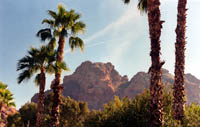
Located
close to downtown Phoenix, Paradise Valley, and Scottsdale
is one of Phoenix's best known landmarks, Camelback Mountain.
The Camelback Mountain trail is a short but moderate to difficult
hike, but is still a favorite for many people in the Phoenix area.
At approximately 2.4 miles round-trip, it is a great hike
for families and others who want to do something local without driving great distances. Do not underestimate this trail. It is
slightly longer than the Squaw Peak (Piestewa) trail, and is also much steeper. Hikers who reach the summit are
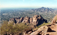
rewarded with incredible views of Metro Phoenix. It certainly
helps put Phoenix in perspective.
 |
|
| |
For Families: |
This is not a newbie hike. If you don't have experience taking your children hiking, Camelback Mountain should not be your first hike. If you want a great starter hike, Pinnacle Peak would be a better option for beginners.
That said, more experienced hikers can take children, depending on how comfortable the children are with heights. Just be aware that there is some exposure to dropoffs, so there may be safety issues for particularly timid or fearless (foolhardy or disobedient) children.
If you have a baby backpack, or other carrier that leaves you with free hands, you will do just fine.
I'm not trying to discourage families from hiking up Camelback — we've been up several times with all ages of children. Mostly just take some precautions. The hike is definitely worth the effort.
|
|
|
| |
|
The
starting elevation is approximately 1,400 ft. Elevation at
the summit is 2,704 ft. That makes an elevation gain of about
1,200 ft in 1.2 miles, which makes for an elevation
gain of approximately 1,000 ft. per mile. The Summit Trail is one short, but steep trail.
The
trail starts near the ramadas and begins by going up some
stairs. Please note that this is the easiest part of the hike.
Shortly after, the trail approaches a steep ascent with handrails. These
can be useful when coming down, since the rock can be slippery. The entire trail is pretty
much a series of short climbs.
Views from the summit are impressive.
Try testing your knowledge of the Valley's landmarks and downtown Phoenix from the
summit. It is possible to see South Mountain, the McDowells,
Superstitions, Sierra Estrellas, and the White Tank Mountains — pretty much all of the mountains that surround the valley.
Many
hikers and joggers use this trail for exercise as well as
preparation for longer hikes.
The Praying
Monk and Gargoyle Wall are favorites formations for rock climbers.
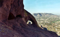
Visitors will notice a number of desert plants such as saguaros,
ocotillos, barrel cacti, palo verde trees, and more. There is even
a small window/arch that is visible on the way down.
The
Cholla Trail is another, longer route to the top. The Cholla Trail has more parking restrictions and has more limited hours than the Summit Trail.
Additional
points of interest include the nearby Papago
Park.
The city of Phoenix has some nice information on Camelback Mountain on their website here.
Climate: Keep in mind this is the Sonoran Desert. Temperatures easily
exceed 110 degrees Fahrenheit (or 43 degrees Celsius) in the
summer. Rattlesnakes, scorpions, and Gila monsters are active
in this environment. Watch for lightning storms as well. It
is highly recommended that hikers and or visitors carry plenty
of water.
Location: Echo Canyon parking lot. This is located
just south of the intersection of Tatum Boulevard and McDonald Drive.
Parking is frequently at a premium, especially on weekends in the cooler months. |