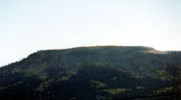
At
10,912 ft., Escudilla is one of Arizona's higher peaks, and
is in a designated Wilderness Area. Escudilla is a Spanish name
for a bowl. Early Spanish explorers in the area apparently
thought its top resembled an inverted bowl of sorts, hence
the name.
The summit is a sub-alpine environment, with Aspen, Englemann
Spruce, and Fir. Wildlife is abundant, with black bears, elk,
deer, and wild turkeys. The last of Arizona's grizzly bears was killed here.
The trail to the summit is a National Recreation Trail. With scenery and views that are sure to please, this 6.6 mile roundtrip
hike is a fun one. The trail
follows an old road that once accessed the lookout tower.
For the first mile or s,o the trail goes through groves of
thick Aspen. The Aspen trees grew after a 1951 forest fire burned 23,000 acres (36 square miles) of pine forest. After the 1st mile, the trail
begins to steepen a little more as it crosses through a meadow
in the Toolbox Draw area. The trail continues on until it
tops Profanity Ridge and then drops slightly. The trail continues
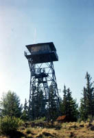
on through meadows and forests of Englemann Spruce and Fir
until it reaches the lookout tower. The fire tower was not actually built on the
summit, although the summit is close by. The structure is at an elevation of 10,876 ft., thus making it Arizona's highest
fire tower.
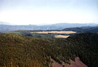
Views from the tower are impressive. New Mexico's Gila Wilderness
can be seen. Mount Graham, the Blue Range Wilderness, Mt.
Baldy, and even the San Francisco Peaks can be seen on clear
days.
Water is usually not available. As of this writing, camping is permitted
everywhere except Bead Springs Meadow
(north of the tower) as this is frequented by bear, deer,
elk, and other wildlife.
Location: Eastern Arizona, south of Springerville/Eager. Take 191/190
south through Nutrioso to Forest Road 56. Follow this approx.
4.5-4.9 miles (depending on odometer) to a junction. Stay
to the left and continue for another 1/2 mile to the trailhead.
From Alpine go about 5.5 miles north to Forest Road 56.
Turn right (east) and follow it 4.5-4.9 miles to a junction.
Stay to the left. It is about 1/2 mile from here to the trailhead.
Weather: Note due to elevation and location, hikers should be prepared for
conditions, as conditions can change rapidly. The significant exposure at the top of the peak makes lightning storms very dangerous.
|