|
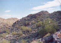
Hidden
Valley, Fat Man's Pass, and the Tunnel are an easy hike into
Phoenix's South Mountain Park and Preserve. South Mountain
Park consists of approximately 17,000 acres, and is considered
by many to be the world's largest city park. The park is also
a preserve, so by law this means that everything within the park
is protected.
 |
|
| |
For Families: |
Fat Man's Pass and the Natural Tunnel are a favorite hike for children. The pass and tunnel are natural playgrounds, and lots of fun for kids.
Just make sure to take care when climbing around on the rocks, since they can be slippery, even when they are dry.
|
|
|
| |
|
South
Mountain Park has many trails.
One of the favorites is a 3.5 mile round-trip hike into Hidden
Valley. This description of the hike starts at the Buena Vista
lookout. From the lookout the Hidden Valley trail follows the National trail east.
The trail follows a ridge for a short distance (approximately
1/2 mile) before reaching a small valley. Continuing on, it
passes through a second small valley (roughly 1 mile). A
sign indicates the turnoff for Hidden Valley (Approximately
1.5 miles).
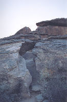
Almost
immediately after turning onto the Hidden Valley trail hikers
will see a narrow passage through some granite boulders. This
is Fat Man's pass. It is approximately 15-20 ft. long. At
its narrowest point, it is 12-18 inches wide. If that is too narrow for you, or you have claustrophobia, Fat Man's pass can
easily be bypassed. The trail then drops into
a small drainage, which is Hidden Valley, and follows the drainage/small wash until
it arrives at the Natural Tunnel. Note: Some of the rocks
in the area are slippery, even when dry.
After
passing through the tunnel, the trail reconnects with the National
Trail. Turn left to return to the Buena Vista lookout. If
you turn right, the National Trail will reach Pima Canyon
at the park's eastern end in about 1.5 miles. Be sure
to enjoy the views of metro Phoenix.
The
area is part of the Lower Sonoran desert. Hikers and mountain
bikers will see Saguaros, Hedgehogs, Palo Verdes, Ocotillos,
and many other types of cactus. Please note: some sections
of the trail are rocky. During the spring, if the area receives
sufficient moisture, it can be especially beautiful with all
of the wild flowers and cactus blossoms.
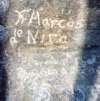
Anciently,
this area was inhabited by the Salado and Hohokam. There are
petroglyphs in the park. Please respect these and do not touch
them. The Spanish also passed through the area. Marcos de
Niza left an inscription on a rock at the park's eastern end
(Pima Canyon). A short hike from the parking lot will bring
visitors to the inscription.
Other
hikes in the park include the Mormon Trail, National Trail,
Javelina Canyon trail, Desert Classic, Telegraph Pass Trail,
Geronimo Trail, Kiwanis Trail, Mormon loop, Alta Trail, Beverly
Canyon Trail, various loops through Pima Canyon, Ridgeline
Trail, Holbert Trail, Ranger Trail, and
the Bajada Trail.
Location: South Mountain is south of Phoenix. US 60 approaches it from
the south. It is located in Central Arizona approximately
2-2.5 hours from Metro Phoenix.
Climate: This is low desert. Summer temperatures easily exceed 100 degrees
Fahrenheit. Hikers should carry plenty of water and be prepared
for conditions. Snakes and scorpions are common in the park.
|