|
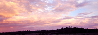
At 11,403 ft., Mount Baldy is one of Arizona's highest peaks.
It is also a designated wilderness area. With scenery and views that
are sure to please, this 13.5 miles roundtrip hike is a fun
one. It has a sub-alpine environment , with distinctive grasses
and trees, such as the Krummholz tree.
There
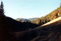
are two good trails to the summit. The best trail is Sheep's
Crossing. The trail begins at an elevation a little over 9,200
ft. and follows the West Fork of the Little Colorado River
for two miles. At this point, the trail turns away from the
river, into an old growth forest, which consists primarily
of Englemann Spruce and Douglas Fir.
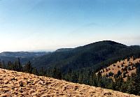
In
the next two miles, the trail becomes steep, and gains about
half of its elevation, bringing hikers above 10,000 ft. Hikers
are soon at a ridge, which is followed to the summit. Mount
Baldy has two peaks, with the lower peak open to the public.
The trail continues approx. 1/4 miles from the ridge to the
main summit.
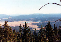
Please
note that the highest peak is not open to the public. The
summit is on the White Mountain Apache Reservation, and you
would have to try to negotiate for a hiking permit prior to
your hike, if you wanted to enter the reservation. The tribe
occasionally will issue permits for the top. Contact the Apache
Indian Reservation for more information before you
make plans to hike into the reservation. The summit is considered
sacred to the Indians. Please respect their lands and customs.
The
turnaround point for the hike is a small yellow sign and USGS
marker. This denotes the boundary between the Forest Service
and the reservation boundary.
Location: Eastern Arizona. Take 260 to 273 (Sunrise turnoff) The paved
road becomes a dirt road at the Forest Service Boundary. Follow
this until you get to the West Fork of the Little Colorado
River. Turn here and head to the road's end at Sheeps Crossing.
Weather: Note that due to elevation and location, hikers should be prepared
for conditions, since conditions can change rapidly in the area.
|