|
The
Peralta Trail is a popular, moderately easy hike into the
Superstition Wilderness Area. The trail leads to Fremont Saddle and a
really nice view of Weaver's Needle.
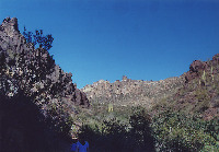
The
trail starts at the base of the Superstition Mountains and
proceeds up Peralta Canyon to Fremont Saddle. The distance from
the trailhead to the saddle is 2.25 miles.
The
trail is easy to follow and is a favorite for many hikers.
The Peralta Trail starts by crossing a small stream in several places, then swinging
from the west side to the east side of the canyon. It continues along the canyon wall, and then to a
small series of switchbacks on the east side before reaching
Freemont Saddle. The elevation gain is approximately 1,400 ft. over
2.25 miles. Elevation at the saddle is approximately 3,700
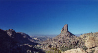
ft. Weaver's Needle is the volcanic plug that visitors see
upon arriving at Fremont Saddle. If you have a good pair of
binoculars, focus them on the summit of Weaver's Needle.
Visitors will be pleased to see an American Flag waving in
the breeze.
Most
hikers turn around at Fremont Saddle. For those continuing
onward, the trail goes north dropping into Boulder Canyon,
and continuing on for several miles before connecting with
the Dutchman's Trail. Past the saddle, the trail isn't as well maintained, and a great deal of boulder-hopping is involved. The Needle itself is a technical climb and requires
special climbing gear, so only experienced rock climbers should attempt to scale the Needle.
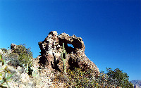
The
saddle also provides excellent views of the Superstition Wilderness.
Also at the top, there are many boulders and caves that are great to explore and climb around. In the area are also a small window and cave on the way up.
Weaver's
Needle is famous due to its association with the "Lost
Dutchman" Gold Mine... or the Dutchman's Lost Gold Mine. Stories say that the Needle could
be seen from the mine... or that the mine is hidden in the shadow of the Needle. The needle can actually be seen from
quite a distance and from a number of locations in and out
of the Superstitions, so don't waste your time looking for the mine.
Climate: Keep in mind this is the Sonoran Desert, and a Wilderness
Area. The best hiking time is from October through May. Temperatures easily exceed 110 degrees Fahrenheit (or
43 degrees Celsius) in the summer. Rattlesnakes, scorpions,
and Gila monsters are active in this environment. At various
times during the year, the land can be susceptible to heavy
flash flooding. Even in the winter, it is highly recommended
that hikers carry plenty of water. Pay attention
to your surroundings and plan ahead for the conditions.
Location: Metro Phoenix. Follow Route 60 east from
Apache Junction to Peralta Road. Head north to the Superstitions
from here. It is approximately 8.0 miles to the trailhead from the
turnoff. Please note Peralta Road passes through a subdivision, and also passes close to a school. Please do not speed while passing
through this section.
|