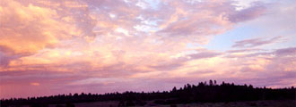
| Cedar
Breaks was established as a National Monument in 1933.
Early
inhabitants called the area the "circle of painted cliffs."
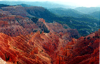
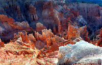
The main feature
is a natural eroded amphitheater that is over 2,000 feet deep
and more than 3 miles in diameter. Cedar Breaks is full of
Canyons with stone spires and columns. To be perfectly honest,
it looks like/resembles badlands. It's many different hues
and colors are astonishing. Minerals such as iron and manganese
contribute to the beautiful colors.
Because
of the high elevation (10,000+ ft/3150+ meters), Cedar Breaks is inaccessible in the winter. A Visitor
Center is located close to Point Supreme (10,350 ft.) The
main road through the monument lies between 10,300 ft and
10,500 ft.
Highway
143 passes through the monument on its way to or from Parowan
and Brian Head ski resort. Spruce and fir forests are dominant
here.
Location: Cedar Breaks National Monument is located in Southwestern Utah in
the high country along highway 148 and 143 east of Cedar City and
west of Bryce Canyon. Please note highway 143 has 13% grades.
|