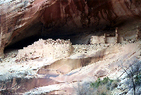
| It
is believed that Monarch Cave was inhabited during the 12th
and 13th Centuries. The main ruin is located in an alcove
on a ledge 2/3 of the way up a small cliff face. It is classified
as a Pueblo III site. Remnants of a smaller ruin are in the
vicinity, please do not cross into this area. Two small trails
lead to the ruin from both sides. Please watch your footing.
The suggested (safest) approach is from the left side.
While this ruin looks nice, it is not very stable. The ruin
is crumbling, so take care with your footing, and don't touch the walls and further de-stabilize the ruins. Some petroglyphs and pictographs are still present.
There is a small stagnant cold pool directly below the main
ruin. While the ruin is not visible until the last possible
moment, it is worth the effort to see the site.
The
American Exploring Expedition of 1892 explored this area.
The name should be on the western cave wall.
Hiking
time is approximately 1-2 hours roundtrip.
Please
note, these ruins have NOT been stabilized. Please do not
remove or rearrange any artifacts. Please do not climb on
the walls.
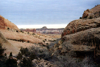
Location: Monarch Cave is located in Southeastern Utah on Cedar Mesa.
The ruins are part of Comb Ridge. The hike does require some
basic route finding. The route and location are not signed.
Climate: This is high desert. Summer temperatures easily exceed 100
degrees Fahrenheit. Winter temperatures frequently go below
freezing. Hikers should carry plenty of water and be prepared
for conditions.
Other
ruins are located in the vicinity.
|