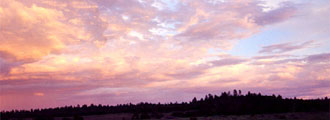
| Nine Mile Canyon is considered
by many to be the world's longest art gallery. It contains
a substantial number of rock art sites. The area appears to have been an ancient thoroughfare. Today
it is a backcountry byway.
The name is misleading since the canyon is over 40 miles in
length. There are several stories as to
how the canyon got its name. According to one story, 9 mile
canyon received its name from a government surveyor who left
his ninth mile marker at the canyon's mouth. Another story
states a topographer who was with the Powell expedition did
a 9 mile triangulation and called it 9 mile creek.
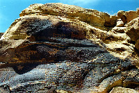
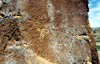
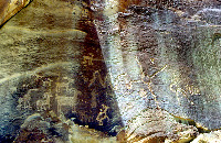
The
rock art consists primarily of petroglyphs (designs cut into
rock) and pictographs (painted on designs). Most are petroglyphs, and many of these are of the Northern San Rafael Style. They
tend to be rougher and not as well crafted as some of the other styles which are
also present. Many of the nicer petroglyphs and pictographs are
Fremont and Ute. A number of the petroglyphs depict animals
and hunting scenes, while other petroglyphs are anyone's guess as
to what they could represent. Some
of the more famous panels and locations include the hunting
scene, and Rasmussen's Cave, where artifacts and mummies were
excavated.
9 Mile Canyon contains many rock art panels, but it also contains
a coal mine, cowboy and ranching structures, and prehistoric
structures.
Please
respect private property and do not trespass. There are many
sites which are not on private land. A number of rock art
sites are fairly close to the road or within a short walking
distance. They are not difficult to find. These sites are
protected by the antiquities act of 1979. Please do not remove
artifacts from the sites.
It
is recommended that at least 1/2 a day be dedicated to touring
the canyon.
Location: The canyon cuts through the Book cliffs and a portion of the Tavaputs
plateau. It is a National Byway. To reach it, follow highway 6/191
to Wellington, Utah. Follow 6/191 east for approximately three miles
to Soldier Creek Road. There is a Chevron station at the intersection.
It should be signed. Follow the road for 12-13 miles until the pavement
ends at or near the coal mine. From here the road is dirt. Continue
on to Minnie Maude Creek. It is roughly 21-22 miles from US 6/191
The petroglyphs will begin to appear about five to eight miles from
here. They seem to get better the farther in you go. |